Lindsay, Montana.
On our way to a family event in early summer, we headed to Glasgow, Montana. On the way, we passed through Glendive, Montana where we transitioned from I-94 to highway 200S. Soon after leaving Glendive, we noticed some grain cars on the tracks that paralleled the road. As we traveled along, we found the cars didn’t disappear after the usual mile or so that represents the typical length of freight trains in the upper Midwest. There were breaks in the line of cars all along the way, leaving enough space for a county road to cross the tracks.
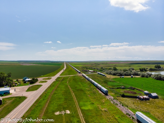
When we got to the small unincorporated town of Lindsay, the cars were still visible as far as we could see in both directions. The opening photo features a view to the east captured from my drone. Lindsay is 23 miles (37 km) from Glendive, so that line of grain cars. Even given that the line of cars started west of Glendive, the line extended well over 20 miles. These cars were obviously positioned along an unused track as a place to store them for future use.
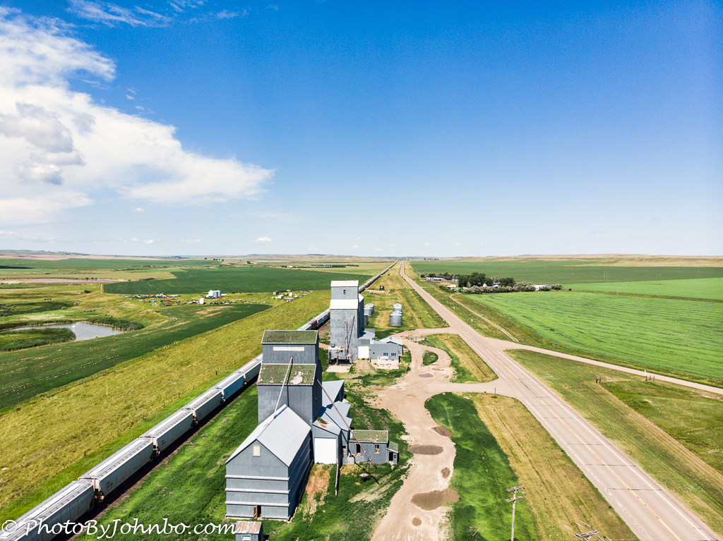
Looking westbound from Lindsay, the line of cars continued as far as we could see as the tracks bypassed a now-defunct grain elevator complex. Of course, the question came up as to why all these cars are in storage. I certainly don’t have an answer. Maybe they get used only during harvest time? Is the ag business so slow due to the pandemic that the railroad doesn’t need all the grain cars this year? The answers to those questions will need to come from someone who is above my pay grade.
In any case, I thought a drone shot would make an interesting photograph of something so unique. Of course, I was careful to not be on railroad property when I launched the drone. The airspace above property, even private property is under the jurisdiction of the Federal Aviation Agency (FAA). Historically, that was not always the case.
Going back to English law, the property above and below a landowner’s bounds belonged to the owner “from Heaven to Hell.” Imagine what an effect that law would have on our aviation industry, leasing airspace from individual owners for the purpose of “trade routes” over individual parcels of land.
A Supreme Court decision in 1946 limited the property above an owner’s parcel to that space which the owner can “protect him from intrusions that would limit the owner’s full enjoyment of the land and limit his ability to exploit it.” The decision, however, did not define a specific height above the ground.
The decision described here was resolved in favor of the landowner due to the property loss incurred. The flights were as low as 83 feet (25 m) above his property as it was near the edge of a military runway.
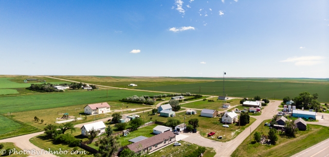
The image shows how small the town of Lindsay is. Its population is 162 according to a Google search. Located in Dawson County, the town has a public school and a post office branch (59339). This image consisted of two shots made into a panorama with Adobe Lightroom. All images processed with Luminar 4.
Drone pilots who fly under part 107 (and are following the FAA’s rules), probably have an advantage over recreational drone pilots. First of all, Part 107 addresses some of the concerns of property owners below the airspace being used. The bottom line for drone fliers is that higher is better, up to 400 feet (122 m) above ground or existing structures.
Above all, create no damage or annoyance to the property owner. My drone flights that day were to a maximum altitude of 117 feet (36 m) and, except for those aforementioned exclusions for the personal use of owned property, the FAA “owns” airspace from the ground upward.
States and other jurisdictions may have more restrictive laws or rules. For these photographs, we launched and kept the drone pretty much along the highway’s right-of-way which in most cases is 33 feet (10 m) from the roadway centerline. In researching, though, I’ve found this number varies widely in different states. Even though you may legally fly over private property, if you have a problem with the drone and have to land and recover it on private property, you could be guilty of trespass. It’s always a good idea to get a landowner’s permission to use the airspace above their property.
John Steiner

If I understand correctly, in the US, it is possible to use a drone freely in corridors 66 feet (20 m) wide by 400 feet (122 m) high along the roads. As these are rules that pre-date the appearance of drones, we can expect an evolution if this mode of transport is to develop.
The 33-foot number I mentioned in the article was measured from the roadway centerline making the corridor 66 feet wide. However, since I saw your comment here, I double-checked.
Different states have different numbers for roadway right-of-way. Vermont apparently has a 49-foot right-of-way (98-ft corridor), and Minnesota (on page 12 of a 321-page document on the topic) has a 75-foot right-of-way (150-ft corridor) for a two-lane road.
Having noted that, I think that the 66-foot corridor is a good rule to follow. If the pilot causes no damage or creates no unwelcome disturbance, that should be a reasonable guide. Just remember, I am not an attorney, and I am not offering this information as legal advice.
Don’t worry, I don’t have a drone to fly 🙂 Thanks for this legal overview.
I always am careful when I quote anything “legal” to make sure it’s a layman’s opinion. >grin<
I am enjoying your site, though I do end up switching to the English version as I've forgotten all my high-school French lessons. 🙂
I really like the drone shots you included, John, especially the one of the train next to the grain elevator. Ah, the complexities of drone use. I think your respectful manner goes a long way in keeping you from having any problems.
Thanks for the comment. If people had operated them respectfully from their first availability, we’d have a lot less restrictions on them than we do now.
I was so tempted to use mine in a National Park on our trip, but the potential fine and loss of equipment kept me legal. >grin<
I did see someone using a drone to fly over a lake in Yellowstone to capture images of a geyser vent that was on the shore. I took a similar image from on land at a scenic viewpoint and the drone wasn't needed at all. They were just lucky (assuming they didn't get caught somewhere else along the line.)
We saw someone use a drone at a National Park facility near San Diego but it may have been before the restriction went in place.
I don’t actually know when the restriction took place either. I’ve only been flying my drone for about 18 months, though I’ve had the FAA license since 2016. Just never used it.