
Buckeye, Arizona.
It wasn’t our first hike on this section of the Verrado Trails, but with a cloudy sky and cool temperatures, it was more pleasant than if it was under the typically hot Arizona sun. The hike is a giant loop clocking in at about 2.5 hours and 5.5 miles (8.8 km). At our 8:30 AM start time, the chilly morning air required layering with a long-sleeved top layer. By the end of the hike, the sky cleared and that top layer could come off. By then, though, we were almost to the end of the trek, so if I recall correctly, our group didn’t stop to adjust clothing.
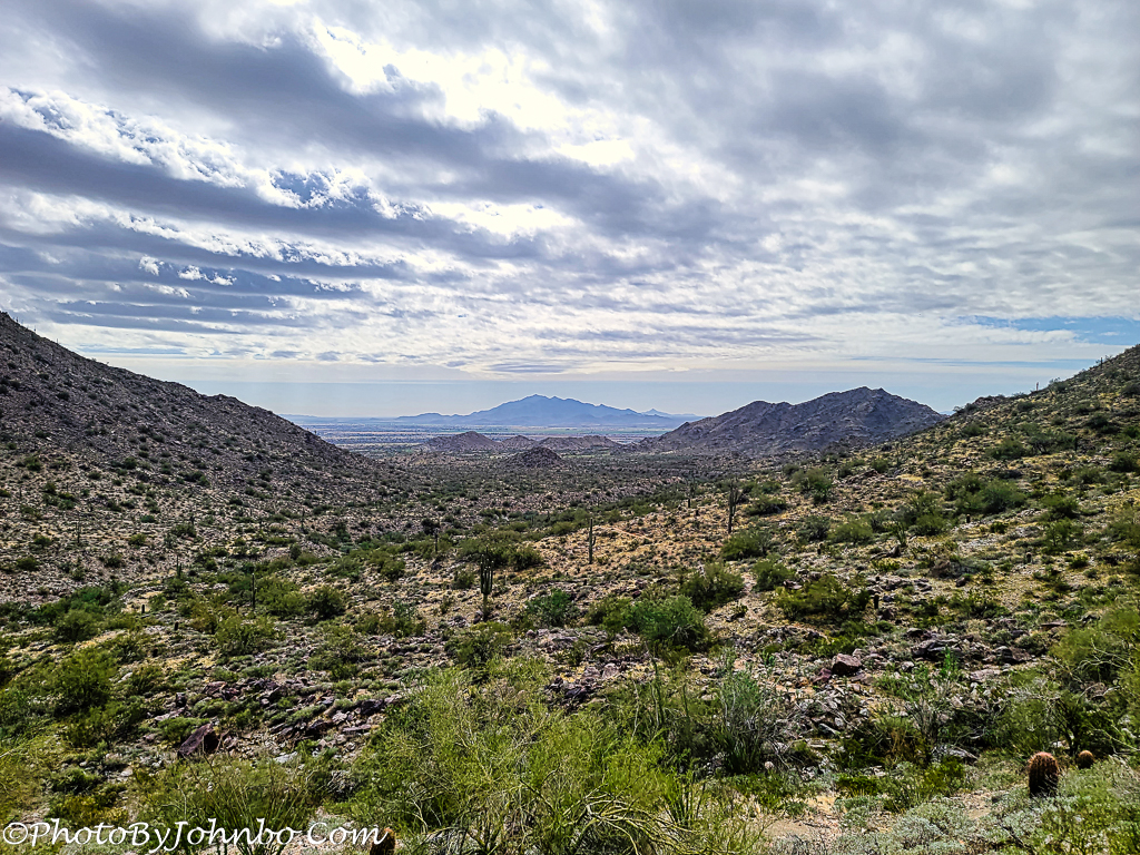
The trail traverses the base of the eastern ridge that is on the left in the image as it goes deep into the canyon. Where the trail ends on that ridge at the northerly end, it crosses the bottom of the canyon, begins a climb along the ridge on the west side and a turn back southerly on a short trail known as Elevator. That trail joins the Highline Trail and meanders part-way up the west canyon wall.
From the Highline Trail, we can see much of the valley that is just west of the Verrado development in Buckeye. Almost dead center in the image is a small knob of rock. The trailhead is a bit north and east of there, but near the conclusion of this loop, we will come within rock-throwing distance of the knob before turning back north toward the loop junction. From there, it’s maybe only a quarter-mile to the trailhead parking area.
Lately I’ve been using an app called “Relive” to provide a visual view of the hike as documented in MapMyWalk, the app I use on my phone to track our progress on the trail and generate stats. You can see the 30-second birds-eye view of our hike here or by clicking on the map below.

About the photo: Captured with my Samsung S20U, the cellpic features an important landmark to my wife and me. At this point along the way, the terrain to the southeast presents an unobstructed view of Estrella Mountain in the distance. Over the years, we have wandered many of the trails in the park on the northwest side of that mountain. On those trails, we marked nearly three-quarters of our first “100-miles in 100 days” challenge. As usual, the image was brought into Adobe Lightroom for cataloging and basic tweaks, then finished in Luminar AI.
John Steiner

That’s a good hike!
My wife, a friend, and I went on a shorter version of this hike last week as well. Love those views of the canyon.
I can almost breathe in the fresh air, so clear is your image!
We are past the cool mornings now, lows in the 20s C. Time is coming for us to head back north before we get those 40 degree C plus highs. 🙂
Temperatures like those can be taxing!