Phoenix, Arizona.
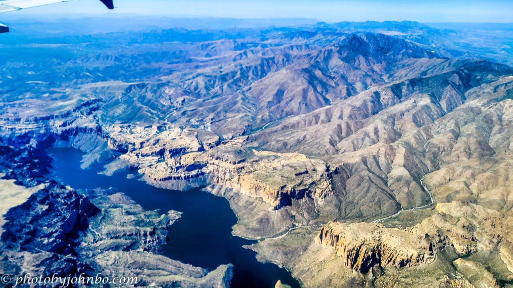
Last week I featured the first of several images taken on my incoming flight to Phoenix in early April. That image of Roosevelt Lake and Dam began the series. Only a few moments southwest (at passenger jet speeds), I captured much of Apache Lake, the second of four reservoirs on the Salt River. Horse Mesa Dam isn’t visible in this image as it’s “around the bend” at the upper left end of the lake. According to the information provided on the Salt River Project website, the dam is some 305 feet (93 m) tall and generates electricity from three hydroelectric generators. You can find more information about Horse Mesa Dam and Apache Lake here.
About the photo: About the photo: Captured by my Samsung S20U, I processed it in Lightroom and Luminar Neo. I had to crop out a bit of the aircraft window at the bottom of the image. As we flew over the area, we were too close to the upriver side of the lake for me to capture its entire length. Click on the image above to view it in 2K HD on my Flickr site (and see the gallery of Cellpic Sunday images from this Flight to Phoenix series.)
I encourage fellow bloggers to create their own Cellpic Sunday posts. I never have a specific topic for this feature, and the only rules are that the photo must be captured with a cell phone, iPad, or another mobile device… If you have an image from a drone or even a dashcam, that’s acceptable as well. The second rule is to link your challenge-response to this post or leave a comment here with a link to your post in the comment.
John Steiner

Majestic John!
Love the mountains and curvy lake.
What exactly is the salt river? Why the name salt river?
I didn’t know the derivation of the name until your question made me look it up. 🙂
Near the headwaters of the river, salt deposits were used by the Native Americans to cure meat and for other typical purposes for salt.
Though it is a fresh water river, it has a higher concentration of salt than most due to these deposits washing downstream.
Thank you John for the information.
Nice shot. The lake looks so desolate.
Thanks, Chris!
[…] John’s Cellpic Sunday […]
Amazing landscape 🙂
I love the beauty of the southwestern United States.
[…] Cellpic Sunday […]
Great shot! Nicely processed.
Thanks, Amy. It is hard to get a decent composition out of those small airplane windows. If I do, I call it mostly luck. 🙂
[…] Johnbo’s CellPic Sunday […]
[…] Shared with #SpringFestival2022, #PPAC, #SundayStills, #CellpicSunday. […]
Aerial shots like this are way cool, John. I agree with someone that the area around the lake looks desolate, but the deep blue is amazing! Here’s mine this week, and thank you for hosting: https://secondwindleisure.com/2022/05/15/sunday-stills-what-is-that-aroma/
I really felt lucky that our route of flight allowed me to capture aerial views of these four reservoirs on the Salt River.
That lake looks full, with no bathtub rings!
In the midst of the drought, those dams are taking advantage of the water sources for power and drinking in the Phoenix metro.
Phoenix can no longer depend upon the Colorado River and with these lakes, and Pleasant Lake on the Agua Fria River, the fast-growing metro area has a chance to survive the challenges ahead.
Another beautiful shot, John. The mountain range and lake look amazing.
Here’s my entry for Cellpic Sunday this week: https://natalietheexplorer.home.blog/2022/05/13/sakuras-and-fleurs-de-villes-2022/
That really is such a rugged landscape, and if it wasn’t for the dam one could easily imagine that no human has set foot there before.
Indeed, what I find fascinating is that Native Americans lived in the area for centuries before the Europeans “discovered” it.
[…] post is part of John.S’s CELLPIC SUNDAY photo […]
[…] My entry for Cellpic Sunday […]
Magnificent mountains.
Indeed!
I haven’t seen that part of the Salt River but we’ve seen the part in Tonto National Forest. Looks as though the water level is quite a bit below normal, which wouldn’t surprise me.
[…] Weekend Coffee Share, Cell Pic Sunday, Flower of the Day […]
What an amaziing view 😃 Here’s mine: https://jezbraithwaite.blog/2022/05/16/pull-up-a-seat-and-enjoy-the-rhododendrons/
It’s an interesting landscape!
It is, indeed. Not hospitable at all in those hot Arizona summers.
I can imagine that 😀
[…] Posted for John’s Cellpic Sunday […]
So beautiful…!
Here is mine:
Thanks, Sofia!
[…] The roses on the west side of my house are now over six feet tall. I’ve shared photos of other pink roses in my gardens, but these are particularly interesting due to the tightly packed petals. I used my iPhone 12 Pro Max to capture the abundance of these roses; sharing for Cee’s Flower of the Day (FOTD) and John’s Cellpic Sunday. […]
Great shot of the lake! It’s always neat to see those lakes and the Salt River when flying in or out of the east. Here’s mine for this week: https://peacefulatdawn.com/2022/05/16/fotd-may-16-2022-pink-roses/
Thanks, Dawn. Those lakes really stand out in the desert that surrounds them.
They sure do! 😎
[…] John’s Cell Pic Sunday […]
Wow! Very Good picture of the lake from the plane!
Thanks, Robert!
Wow, Arizona is such a rugged area everywhere you look. That’s quite a trip into the lake by car. I checked out their website. Have you ever gone there in person? I love your picture from the sky.
It is a long drive to visit those lakes. The only lake we’ve visited is Canyon Lake. If you go there, take the Dolly Cruise, but get your tickets in advance. They often sell out before sail day.
We haven’t been there. It is a fair drive from Prescott – about 4 hours, the same as to Palm Desert. We may go there in June, but I’m not sure I want to do a cruise in mid-summer. We did a train ride (on my WQW post today) in Valley Verde in the mid summer, and wow, we were both rung out.
We did the Valley Verde train in the winter, and it was a very comfortable ride.
I don’t blame you on not taking the Dolly during the summer. In fact, I’m not even sure of their schedule. They may only operate in the cooler months.
That sounds more like a plan.
[…] Johnbo’s Cellpic Sunday Photography Challenge. […]
[…] CELL PIC SUNDAY […]
[…] Cellpic Sunday […]