
Phoenix, Arizona.
A note for my regular Cellpic Sunday contributors:
Lynn and I are in North Carolina this week visiting family. Our son and his wife live in a semi-rural area with minimal Internet service. Their cell phone coverage for our carrier is weak so my usual remote hot spot connection isn’t reliable. Please expect a delay in my responses to your comments and Cellpic Sunday responses. We will be home again in a couple of days.
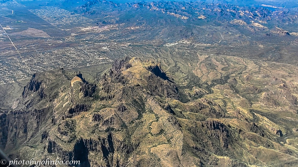
Phoenix is located in a large, flat area that is known as the Valley of the Sun partly because it is ringed by several small mountain ranges. Probably the most well-known range is the Superstition Mountains which lie on the eastern boundary of the valley. Colocated with the Tonto National Forest, these beautiful volcanic mountains tower over the community of Apache Junction and draw thousands of adventure seekers each year for hiking, camping, and other outdoor activities.
Though not particularly tall, these peaks top out at only 5,000 feet (1524 m) or so, the volcanic peaks are visible for many miles. Indeed, even on not-so-clear days, the Superstitions are visible from Buckeye at the extreme west end of the Valley of the Sun.
The Superstitions hold many secrets and many legends, probably the most enduring are the stories told of the Lost Dutchman Mine. According to legend, a lone prospector discovered a particularly rich stratum of gold. He worked in the mine until his death but the location of his find was lost to the ages when he died. Many have died in those mountains while searching in vain for those vast riches. It’s easy to start following the many trails from the west and south edges of the range, but hundreds have entered, never to return.
About the photo: As we flew just south of the mountain range, I recognized it immediately. It is, by air, only a few moments south and west of Canyon Lake. Captured by my Samsung S20U, I processed the image in Lightroom and Luminar Neo. The photo doesn’t do the mountains justice as our altitude tends to make the terrain look relatively flat. If you look to the left in the photo, you’ll see those incredibly small houses in the Apache Junction and Mesa communities. Only then can you get a realistic scale as to the size of these magnificent mountains. Click on the image above to view it in 2K HD on my Flickr site (and see the gallery of Cellpic Sunday images from this Flight to Phoenix series.)
I encourage fellow bloggers to create their own Cellpic Sunday posts. I never have a specific topic for this feature, and the only rules are that the photo must be captured with a cell phone, iPad, or another mobile device… If you have an image from a drone or even a dashcam, that’s acceptable as well. The second rule is to link your challenge-response to this post or leave a comment here with a link to your post in the comment.
John Steiner

My only view of Phoenix was from a plane about to land (it was a flight which hopped from elsewhere to elsewhere, while depositing a few people in Phoenix). Very similar view. Beautifully detailed. So much better than the phone cameras of a decade ago could capture.
I noticed that I even forgot about switching my phone into its highest pixel mode. I was disappointed that they wouldn’t be detailed. They turned out just fine. 🙂
[…] John’s Cellpic Sunday […]
Rugged terrain to look for gold. 🙂
Indeed. Many have searched and in the process lost their lives.
An interesting shot! I always like looking down at mountain ranges when we fly over them. Yes, the angle tends to flatten out the sense of their height, but the ridges and valleys make for interesting shadows and contrasts, almost abstract at times 🙂
You’ve hit on the one negative of aerial images, the flattening of terrain. It takes a dynamic landscape to overcome that obstacle.
True – and low morning or evening sun helps too 🙂
Great shot. We took a Jeep tour here years ago. It’s interesting to see it from the air.
We’ve hiked in the mountains as well, so we know how it is much larger than the view from the airplane. 🙂
[…] Cellpic Sunday May 29, 2022: […]
Those are spectacular looking, very rugged 😃 Here’s mine: https://jezbraithwaite.blog/2022/05/30/rhodie-and-a-bee-cellpic-sunday/
Enjoy your tiere with your family!
time there
Thanks, Aletta!
[…] Posted for John’s Cellpic Sunday Challenge […]
Another amazing photo, John and what a name for mountains!
Here is mine:
It is truly an appropriate name! Thanks!
[…] post is part of John S’s CELLPIC SUNDAY photo challenge. The photo was captured with one plus 6 mobile […]
[…] John’s Cell Pic Sunday […]
[…] Cellpic Sunday Jun 5, 2022: […]