
 Panama Canal.
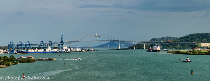
Upon the completion of the Panama Canal, the world realized that the northern and southern Americas would be permanently split. More importantly, the cities of Colón and Panama City would be separated from the rest of the country. Ferries were used at first, then a couple of other swing bridges provided limited traffic passage between the two separated areas. Eventually, the U.S. government agreed to the construction of a 20 million dollar bridge that would be part of the Pan American Highway. Construction started in 1959. A completion ceremony took place on October 12, 1962. The opening image features a view of the bridge captured from the front of the cruise ship Norwegian Pearl on our canal cruise in 2013. As it is a panoramic image, clicking on it will bring you an enlarged view (in most browsers.)
Originally, the bridge was named for the ferry that provided a connection to the two continents before the construction of the bridge. The Thatcher Ferry Bridge was already renamed Bridge of the Americas before its inauguration. According to an article about the bridge in Wikipedia (where most of this post’s information is sourced), by 2004, the bridge was carrying 35,000 vehicles a day. Details about the bridge’s cantilever construction and history can be found in that article here.
![]() In 2019, on our second trip through the canal, I captured images of the northern end of the bridge as we went under it. In 2013, we traveled from the Atlantic to the Pacific. In 2019, we traversed the canal in the opposite direction. The opening photo shows the view to the west as we traveled toward the Pacific Ocean.
In 2019, on our second trip through the canal, I captured images of the northern end of the bridge as we went under it. In 2013, we traveled from the Atlantic to the Pacific. In 2019, we traversed the canal in the opposite direction. The opening photo shows the view to the west as we traveled toward the Pacific Ocean.
![]() Looking straight at the reinforced concrete support structure, we could see the diminishing size of the supports.
Looking straight at the reinforced concrete support structure, we could see the diminishing size of the supports.
![]() The final shot in this view under the bridge gives a better view of the supporting superstructure.
The final shot in this view under the bridge gives a better view of the supporting superstructure.
John Steiner

This bridge is so essential for world geography and biodiversity. It is worth noting that there is no toll unlike many bridges of this magnitude. We know the story, first the tolls pay for the construction costs, then the tolls stay in place to pay for the maintenance costs, and finally to pay for the tolls cost.
When people had to be hired to operate the booths, it was a lot more expensive than these days when technology can be used to collect the tolls.
In Fargo, we had a neighborhood that wanted a closer crossing of the Red River into Minnesota than the existing bridges. A project was put together and approved for a toll bridge to be constructed.
I think the tolls were $.25, but it could have been $.75 (I don’t remember.)
Eventually, the city found the funding to purchase the bridge and it became part of the city infrastructure. The toll booths were removed.
Great photos from some unique perspectives! Will you also tell us about the second and newer Centennial Bridge?
I was unaware of the significance of the Centennial Bridge until they were preparing to cross underneath it on our last passage. At that time, I happened to not be in a space where I could get any photographs.
It looks like that post will have to wait for my third trip through the canal. >grin<
That’s an elegant bridge 🙂 I’d love to sail through the Panama Canal one day!
It is a fascinating journey on a cruise ship. Narrated on the ship PA system, you learn a lot.
Yes, I can imagine you would – oh well, some day …
A suitably impressive name for a very important piece of infrastructure!
Indeed!
[…] The Bridge of the Americas – Rejoining Two Continents — Journeys with Johnbo […]