Fargo, North Dakota.
It’s finally getting warm enough for the snow to melt in the state. In fact, in the eastern part of the state, the snow is all but gone. However, the water that it was storing has to find its way to the rivers. The rivers rise and begin flowing out of their banks threatening towns and farms that are near the river’s edges.
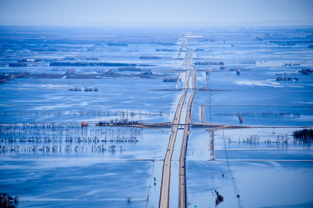
The photos in this post were all captured May 4 and 5, 2022. The opening photo demonstrates the extent of the overland flooding in the northeastern part of the state. I-29 generally parallels the Red River of the North from Pembina at the Canadian border south through Grand Forks and Fargo to the South Dakota border, and points south.

Around the city of Grand Forks and throughout the northern and western parts of the state, water is standing in the fields because the rivers are full. In the Minot area, for example, an April blizzard brought around four feet (1.3 m) of fresh snow on top of what was already there.

Last week, flight crews were needed in North Dakota to capture the current river conditions for several critical areas in North Dakota. It’s no secret on these pages that I am a volunteer for the Civil Air Patrol, an all-volunteer civilian agency that works with FEMA, the United States Air Force, and various departments in state governments. In North Dakota, our main contact is the North Dakota Department of Emergency Services.
To put some faces on the volunteers, the image above is from a few years ago, taken during hurricane damage assessment flights in Houston, Texas. Though flight crews vary depending upon the situation, our crews normally consist of three members, the pilot, the observer (who may or may not be a pilot), and the aerial photographer. I was the pilot on a few of those flights over Houston. In the photo, the observer, (also a pilot on our crew) was in the background checking the engine oil, and the airborne photographer was checking the camera and gear in preparation for the many photographs he would be taking.
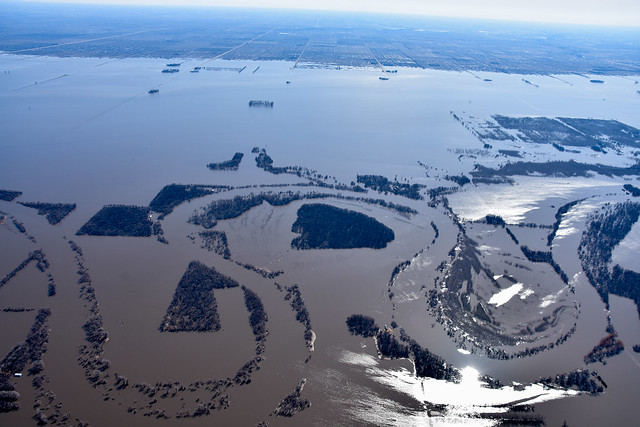
The flood photos above were captured by another flight crew in Northeastern North Dakota. In this image, it is easy to see the normal path of the river by following the two parallel tree lines as they snake through the image winding from left to right.

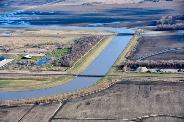
So far this year, I’ve flown one photo flight, this time as an airborne photographer. Our assignment was to capture images of the rivers and flood protection projects in southeastern North Dakota. Our flight path would take us over the Red River around Fargo, then we would follow the Sheyenne River south and west to Valley City and conclude with images of the Bald Hill Dam.
In these images, captured May 5, you will see that this part of the state has far less severe flooding than some other areas of the state. The Veterans Bridge is on the left in the photo above. Directly to the right is the Burlington Northern Railroad Bridge, and immediately right of that is the NP Avenue Bridge. In the upper right corner, the 1st Ave North Bridge spans the river which is also the state line between North Dakota and Minnesota. You may have noticed that the river is just slightly out of its normal banks under the NP Avenue bridge. You can see one of the roads under the bridge is underwater.

A bit further north along the Red River, the Oak Grove neighborhood is well protected with dikes on the west bank of the river which is clearly out of its banks in this part of the city.
In the suburban community of West Fargo, the Sheyenne River flows right through the center of town. In 1992, a flood mitigation project was completed that diverts the bulk of the floodwaters into a diversion that flows west of the city. As you can see by the image above, the diversion is handling the excess water. One interesting design of the diversion is that on the east (left in this photo), the diversion is higher than on the west. If the diversion does overflow, it will spill to the west onto open farmland rather than east into the city.

On our sortie, we captured an image of the dike protecting the city of Mapleton from the Maple River, and captured images along the Sheyenne near Horace, Kindred, Lisbon, Fort Ransom, Kathryn, and Valley City before we concluded the project with a series of images of Baldhill Dam.
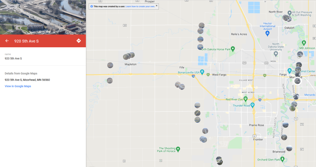
To see these photos in the context of the area where they were taken, you can click here to view image icons on a map. On that Google map page linked above, click on a circular image icon to see a small version of the image, and click on the image that appears in the upper left corner to see a full-screen view.
I will conclude this post with an invitation to join the volunteers in Civil Air Patrol (CAP). Many people believe CAP is only interested in pilot volunteers. That is not the case. We have a large percentage of members who are involved with radio communications, digital cellular emergency location services, and aerospace education. CAP is also building the largest fleet of small unmanned aerial systems (drones), and we have a great need for aerial photographers and drone pilots. Training is provided, and generally, the members use equipment supplied by CAP rather than their own personal equipment. CAP members in the cadet program range in age from 12 to 18, and our regular membership is open to all ages from 18 up. Visit a local squadron to learn about CAP’s programs for your community. Click the big red button underneath the main photo on this page to find a local squadron in your area.
Photo credits: The first three images of flooding were captured by another flight crew on assignment over the Red River in northeastern North Dakota. All remaining flood images were captured using a Nikon D7200 with Sigma 18-200 lens by yours truly. You pixel peep at these images in 2K HD by clicking on any image above or by visiting the entire album here. All flood images are the property of the North Dakota Department of Emergency Services, used with permission.
John Steiner

From your impressive photos, these floods appear to be on the scale of those we used to have in the Mekong River delta.
We’ve been lucky for the last few years (floodwise, but unlucky droughtwise.)
This year, I think most of the farmers will be happy with their renewed water tables.
This year is an above average flood year, but we’ve seen much worse.
Wow, amazing post John. And to think here in California we need some of that water. However, I do remember a year when it rained every day for a month. The American River had crested and flooded Discovery Park. I live in a State that’s either feast or famine when it comes to weather.
I’d be happy to ship you some of our excess water, but I’m afraid the local farmers wouldn’t feel so magnanimous. 🙂
😃
The floods in your first few photos are really amazing – and no doubt devastating for anyone whose property is under water. Flooding is a growing problem here in the UK, in certain areas. In the past planners didn’t consider flood plains when deciding where to build and communities are paying the price now. I don’t think we have anything like your Civil Air Patrol. Mapping of flooding impact here would be done largely by the Environment agency I believe.
Thankfully, so far the damage to property in North Dakota is relatively limited this year. Certainly that’s a blessing partly accomplished by flood mitigations after the 1997 and 2009 floods that were much more severe.
We have just had terrible floods leading to over 450 deaths in this country, with dozens still missing, and terrible damage to infrastructure and ligistics. Your photos are a reminder to us all that neither the rich or the poor will be unaffected by climate change.
I am sorry to hear that. The war in Ukraine has pushed almost all other world news to the background here in the U.S.
Amazing shots and an interesting education on how different parts of the country deal with flooding, irrigation and drought. La Nina delivered a wet cold winter here in WA which was sorely needed. I have to agree with Anne’s comment about Sacramento and the feast or famine weather there after almost 60 years of living in it !
It truly is interesting how weather patterns affect different parts of the country. We can use the moisture here, but there are plenty of places that didn’t get any relief from the drought.
Oh my! This is something that did not make our Canadian news here in Ontario. I’m glad the farmers will be happy with increased water. That’s the silver lining.
We are still at high water stages here, but at least it is going down and less threat to property every day.