

Great Salt Lake State Park, Utah.
A few miles outside Salt Lake City, a state park on the shore of the Great Salt Lake invites people to visit and learn about the lake and why it is so salty. In late December, we visited the Great Basin National Park and learned that much of the western desert region is in a series of low-lying areas collectively known as the Great Basin. Salt Lake is in one of those basins and is the largest saltwater lake in the Western United States.
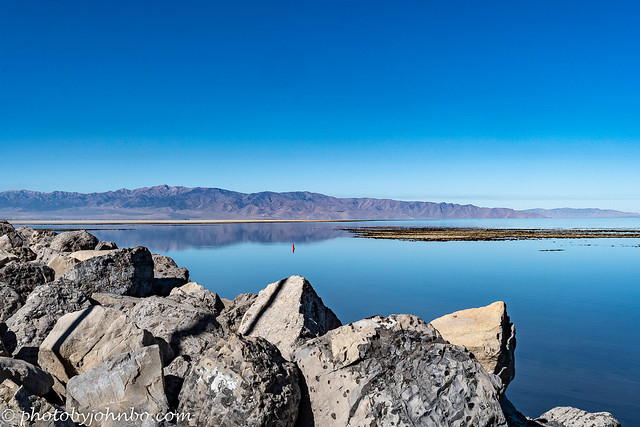
The Great Salt Lake is actually a remnant of Lake Bonneville which existed some 75,000 years ago. Back then the areas where I stood to take these photos were over 1,000 feet (304 m) below the surface of the lake. When we were there in the fall of 2021, I was amazed at how low the water level was at that time. You’ll note that some of the beach images have large areas of sand that in recent years were covered in water. I put two and two together to realize that the test track at Bonneville Salt Flats must be nearby and that they are on the dry lake bed of Lake Bonneville.
An article from NBC news and posted on the Yahoo News site dated December 7, 2022 points out that water levels are at the lowest levels on record and are creating a toxic dust hazard for the residents of nearby Salt Lake City. Once active marinas are now abandoned as there isn’t enough water to float the boats in those areas. The article goes on to say that the low lake levels aren’t simply caused by global warming. The lake’s several source rivers are being depleted by the consumption of river waters for agriculture, industrial, and residential use. The article can be found here.

The image above is taken at the entrance to the marina at the Great Salt Lake State Park and Marina. There were a few boats in the marina on the day we visited, but they were not of any size. The water level at the entrance to the marina precludes all but smaller boats from entering there.

The state park is quite small, but it has several viewpoint areas where you can take photos of the lake which is as much as seven times saltier than the ocean. The high salt content is due to the fact that the lake has no outflowing rivers. Natural evaporation in the desert environment leaves mineral deposits from the many rivers that flow into the lake. The map above describes views of the nearby islands so you can identify them as you look out over the water.
There is a small entrance fee to enter the park and you can self-pay if you have cash with you or you can pay your admission online in advance. On the day we arrived, we met a friendly park employee who collected our fee and directed us to the parking area.

At one point, there is a trail down to the beach level from the slightly higher level of the state park property. From here, we could see plenty of people walking the beach to the edge of the water. There were several school buses that arrived while we were there and most of the visitors were students from those buses.
The park is open winter and summer but you should check their website here for details. Yet again, I wish I’d checked the website before showing up at the park. Drone use is allowed with the payment of a fee. I’m not sure why I didn’t ask the attendant. Certainly, an opportunity was missed.

Looking out over the beach, I could see this unusual building and wondered what it might be. On our way out of the park, we went by it to see signage that might indicate its function. There are no outward indications as to the function of the Moorish-style architectural building.

Google maps, however, lists the building as a music venue. The Great Saltair was a resort and amusement park and the first building was built in 1893. Lost in fires, the first and second buildings were replaced by the building in the photos above. This third building was built in the 1980s. The resort and amusement park are both gone, but concerts are still held in the facility.
Be sure to click on any of the images above to get a better view in 2K HD on my Flickr site. Or you can visit the entire album here and scroll through the images.
John Steiner

That is a wonderful place John. Pity that the levels are screwed by people. Did you find the bit where the speed records were made?
We saw the signs pointing in that direction, but our next stop on our trip was in a different direction, unfortunately.
Oh well no records for you then John 🏎️ 😂
Indeed!
Oh, wow!
Gorgeous images and interesting editorial. Thanks for sharing.
Thanks, Dawn!
Wow, such still water and perfect reflections! Your opening panorama is stunning 😮
Thanks, Sarah. Those low water levels mirror other major lakes in the region.
Interesting read John.
Sadly, people make fun of Global warming!
Love the clicks and panorama.
Indeed. It’s sad that people think opinion is as valid as researched knowledge.
Thank you John.
It’s so sad that the lake is shrinking. I’ve never actually seen the lake up close. Sounds like I should visit before it shrinks even more.
Maybe the rains out west this year will help to keep it from losing more at least for awhile.
The recent snowfalls are raising the water level of the lake, and that’s expected to continue until April of 2023: https://www.abc4.com/news/local-news/rainy-days-in-utah-are-raising-water-levels-at-great-salt-lake/
That would be helpful, Hien!
Great images John. We’ve driven by the Great Salt Lake, but never stopped.
Thanks, Anne!
Thank you John, they are all wonderful pictures, again thank you for sharing. Love al of them.
Thanks, Eithnea!
How worrying to see such a striking natural feature being depleted by over consumption!
Indeed!
I’m taking notes as we will pass through there and back from our road trip in late March through mid-April. I’ve never stepped foot in Utah, so this will be fun. Gorgeous views you share here, John. Sad to read the water levels are so low.
Thanks, Terri. Have a safe trip!
Beautiful images, John! It’s so sad to hear the low water level.
Thanks. It is sad.