
Keystone, South Dakota.
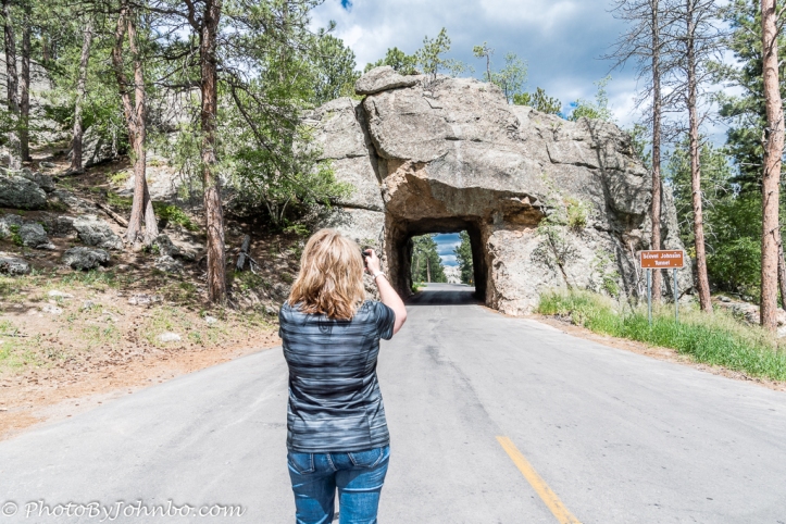
What’s so special about that tunnel in the opening photo that would cause a perfectly normal person to stand in the roadway to take a photo (and for someone to stand behind her to take another photo?) Look closely inside the tunnel. Here, I’ll help you. Check the photo below using my zoom lens.
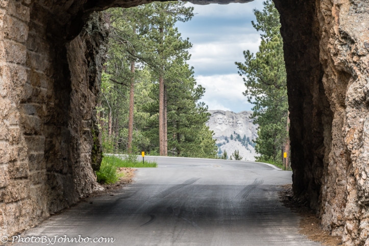
Yes, the Scovel Johnson Tunnel acts as a frame to photograph Mount Rushmore. The Iron Mountain Road was built specifically to showcase what is probably the most popular monument in South Dakota. Known officially as Highway 16A, this 17-mile stretch travels between Custer State Park and Mount Rushmore. But don’t plan on it being your normal 17-mile, 17-minute trip. Take at least an hour to savor the 314 curves, 14 switchbacks, 3 tunnels and several views of the 4 presidents.
Let’s start back at the beginning. In Last week’s Travel Tuesday post, we visited Mount Rushmore and shared a short scenic drive around the famous mountain. This week, we leave Rushmore traveling back toward the town of Keystone, on our way to find the turnoff for Iron Mountain Road. Stopping in the shadows of Rushmore, I spotted an interesting rock formation and some buildings off in the distance. What I saw is featured in the image above. I wanted a closer look, and my telephoto lens brought me a better image of what I was looking at.
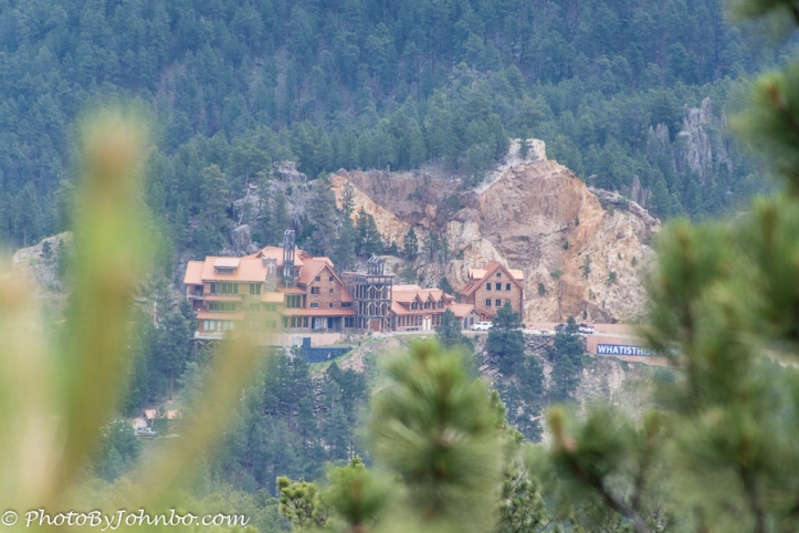 Looking through my camera, I could see what appeared to be some kind of resort in the shadow of a rock outcropping. We didn’t have the inclination to visit or check out specifically what it was, so after grabbing a couple of other photos in this beautiful area, I was back in the car and only a few moments from Iron Mountain Road. It wasn’t until I got home and started reviewing the images that I was to discover the secret of this structure. Reviewing the telephoto image, I noticed a blue sign off to the right. The sign reads “WHATISTHIS4.COM”. Putting that in Google, I discovered the Keystone Project Ministry Center. It turns out that the complex is a Christian religious training center for ministers the world over.
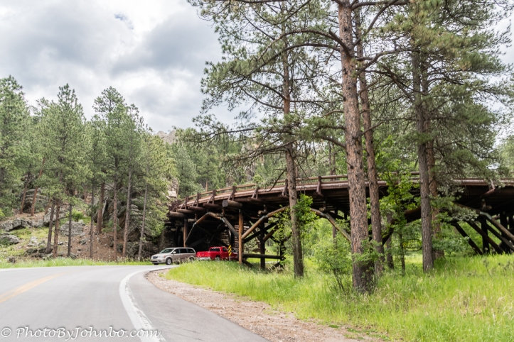
Just down the road from that viewpoint, a sign directed me to Highway 16A and our 17-mile (27 km) journey began. The specially constructed highway includes several bridges that have the purpose of making the road “cross itself.” In only a few moments, we encountered the first bridge. From our approach, it looked like any other bridge where two roads would have otherwise intersected, one crossed over the other. However, just after proceeding under this bridge, the road meanders sharp left and wraps around almost 270 degrees where the bridge begins and you proceed to cross over the roadway where you passed under the bridge.
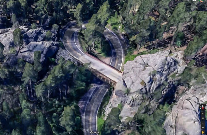
To give you a better idea of what the road looks like on these turns, the 3-D Satellite view from Google Maps above demonstrates the switchback bridge crossing over the highway. The designer’s goal in creating the large number of turns was simply to limit traveler’s speed so that they could slow down and enjoy the beautiful scenery. The star of the show, however, is Mount Rushmore. Tunnels along the highway aren’t the only design elements that showcase the sculptured mountain.
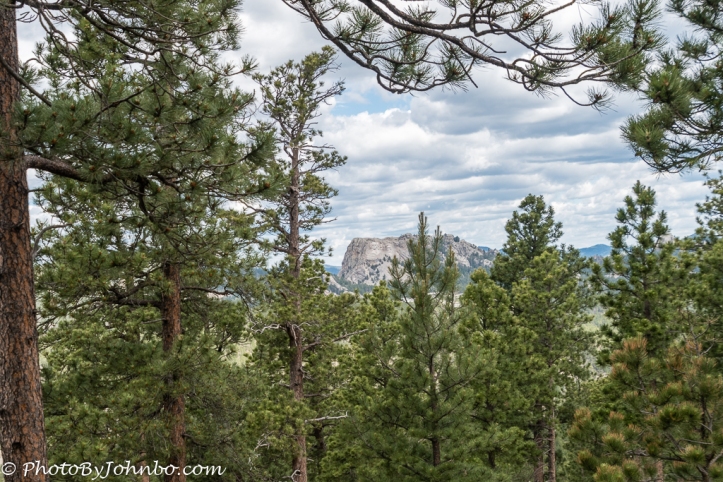
Several of the viewpoints along the way frame the mountain view. The image above is what you might view from a standard camera lens (about 50 mm on an older film camera for those who care).
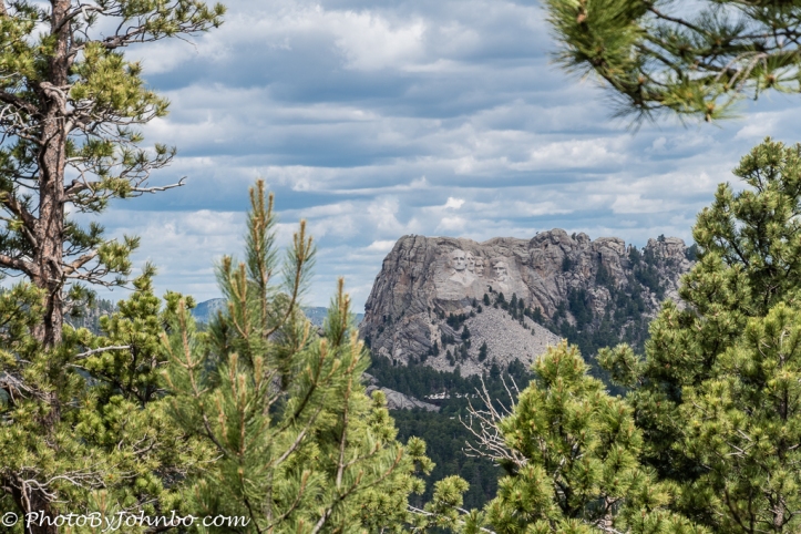
Apply a zoom of around 125 mm for that same camera and you’ll get a pretty impressive image of the mountain. Of course, if you’ve ever taken a photo with a cell phone camera, you’ll note that what your eyes can see clearly, the photo on the camera makes “miniature”. Your own eye’s ability to focus your brain on a subject see the mountain more like the closer view below rather than the fully framed image above it. Take the time to stop and check out all the viewpoints. You might just be surprised what you will see… and it won’t always be Mount Rushmore. If you have the time, drive the road from both directions. It will be a couple of hours well spent on the journey. It turns out that Iron Mountain Road is one of my favorite journeys to date. The images featured in the gallery are but a handful of photos I captured that day on Iron Mountain Road. With most browsers, click or touch an image below to enlarge it and to scroll through the gallery.


John Steiner

Whaaaat, whaaaat?! What a great idea designing the road in such a fashion! At least until someone plunges off because they were appreciating the beauty. Hahaha It’s super cool how that ministry blends into nature instead of dominating it.
Best of all, you get to miss the crazy drivers on the Interstate. 😀
What a spectacular roadway! I definitely need to update my bucket list!
It is quite the Highway!
[…] Custer State Park. In 2017, we traveled the Iron Mountain Road. You can read about that journey here. Almost every trip, we take the Wildlife Loop Road, though I’ve never done a specific post […]