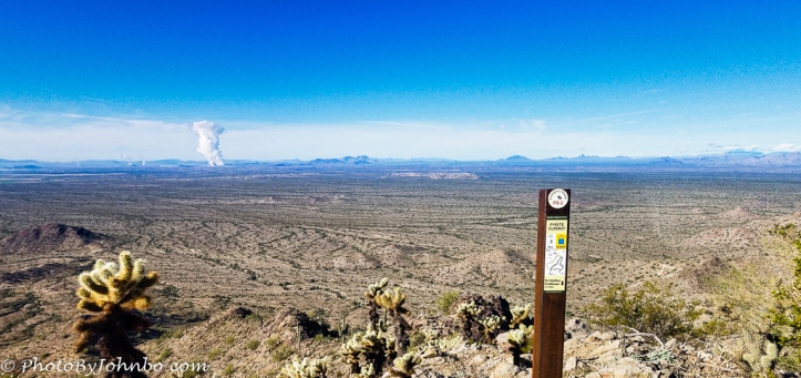
Hiking season has started for me in Arizona. My first hike for the year is at nearby Skyline Park. Pyrite Trail and Pyrite Summit are two of the most recent trails constructed in the park. On December 5, our hiking club’s Thursday hike brought us to the peak that features commanding views to the west. The last segment of trail to the peak is only .3 miles (.5 km) and it rises about 180 feet (55 m). The main trail, Pyrite is 2.1 miles (3.4 km) and rises some 565 feet (172 m) along the route. It is a steady climb with occasional descents through arroyos (washes). The view from the top is over 800 feet (244 m) above the valley floor or 2,149 feet (655 m) above sea level on a topographical map. To get to Pyrite Trail, though, you are required to hike parts of Turnbuckle and Granite Falls trails. The round trip for the day was 7 miles (11.3 km) with an average pace of 30 minutes/mile. The 3 hour, 32 minute hike was a good challenge for my first hike of the season. I am looking forward to more.
About the photo. This summit is one of the higher peaks on the western edge of the White Tank Mountains and has a commanding view of the valley to the southwest. The community in the distance (nearest the trail marker) is Tonopah. Just to the left (south) is Wintersberg. The large plume of steam is from the Palo Verde Nuclear Reactor power plant. The three water reactors create the largest nuclear power generation in the United States. The image is a composite of three photos captured on my Samsung S7 cell phone. The image was edited in Lightroom and Luminar Flex.
John Steiner


Amazing pic! Alas, you are far more adventurous than I as I can’t imagine hiking at all. Different strokes for different folks…
On that hike, I was thinking that if someone told me in 2010 that by 2020 I would be a hike leader in Arizona, I’d have thought they were nuts. You never know where life leads you.
Amen, sir. People are actually quite poor at predicting the future. That’s why so many of us are always being surprised.
Cool John! Is combining 3 photos is a very clever approach!
Thank you! That function is one of my favorite Lightroom features.