Mosier, Oregon.
On last week’s Travel Tuesday, I introduced you to the Columbia Gorge Scenic Byway that features but a sampling of the many waterfalls in the region. The byway also provides wonderful views of the Columbia River as the highway follows the bends of the river. When you get far enough east, you will find yourself back on I-84 at mile marker 35. To see more scenic views of the region, though, be sure to exit I-84 at exit 69 near the city of Mosier.
There you can pick up US Highway 30 again and continue on your way. You won’t find any waterfall stops on this section, and you will find only views of the countryside and that beautiful Columbia River. It’s only about 17 miles (27 km) of the scenic highway from Mosier to The Dalles where Highway 30 ends and you can rejoin the Interstate on your way eastward.
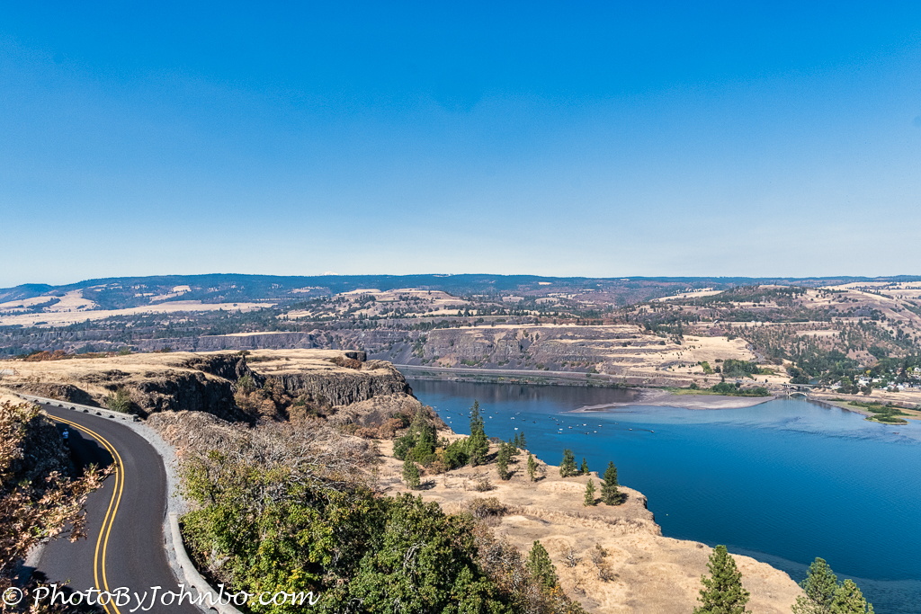
There are two scenic pull-offs that you must not miss. The Rowena Crest Viewpoint provides spectacular views of the gorge. The opening photo features a westerly view from there. You can also see how closely US Highway 30 parallels the river at some points.
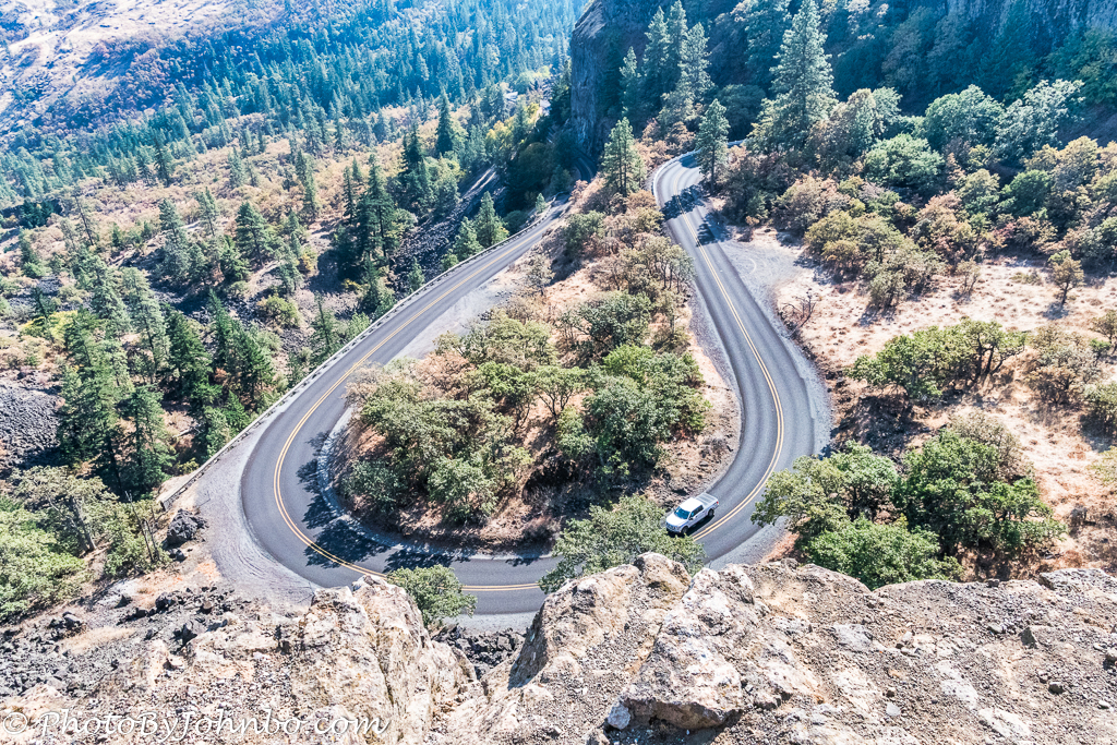
If you look in a direction opposite the river, though, you will find what is probably the most photographed section of the scenic highway. At this point, the highway makes a large horseshoe bend as it winds its way through the Oregon countryside. I may have implied that the scenic highway travels in parallel to the Columbia River, but much of US 30 is inland at this point, part of which is in or near Mayer State Park. The park entrance is and, from there, much of the remaining ride on US Highway 30 is again along the river.
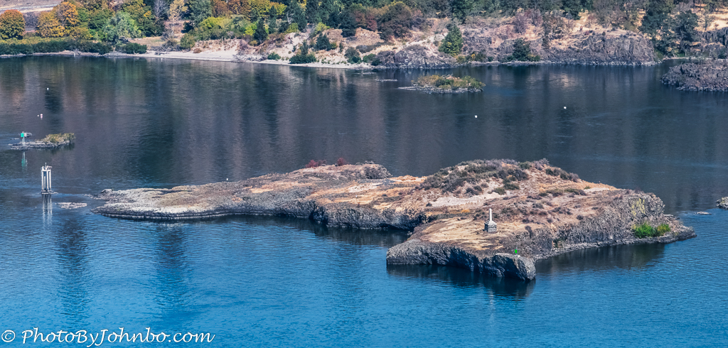
At another viewpoint near Rowena Crest, the Memaloose Overlook, you can see an island on the Columbia River with a tall monument on it. Memaloose Island Rest Stop on I-84 has a plaque with the history of the island. Of course, you won’t see the plaque because you’ll be on Highway 30, the scenic byway. I am happy to share the story with you, information about the island via the Internet.
In 1805 and 1806, Lewis and Clark’s expedition explored islands along the Columbia. They found many islands contained the remains of Native Americans. At that time, their dead were not buried but were wrapped in robes, placed in canoes or cedar vaults, and placed in the woods or on islands in the river.
On this island, when Lewis and Clark passed by, they found thirteen sepulchers on the rock. They named the island “Sepulcher Island.” Eventually, the name was changed to “Memaloose” which is derived from a Chinook word meaning “to die.”
Quoting from that placard, “The lone monument visible on Memaloose Island marks the grave of Victor Trevitt, a pioneer printer, businessman, state legislator, and friend of the Indians. Trevitt requested burial here among the people he loved. Ironically, water rising behind the Bonneville Dam prompted the relocation of Indian graves during the 1930s, but Victor Trevitt’s grave remains.”
For hikers, across the road from the parking lot at the Memaloose Overlook, there is a 3.5 mile (5.6 km) trail. The trailhead is unmarked, but the path and hike details are here. The out-and-back hike is rated Easy and it is open year-round, but the article recommends April or May for spectacular views of wildflowers in bloom.
John Steiner

The photos show a rather dramatic landscape around the river. Are they taken with the drone or from the ground?
The viewpoint at Rowena Crest is high on a bluff overlooking the river. No drone needed to capture those images. They were taken with my D500 Nikon.
Thank you for reminding me of our beautiful drive along the Columbia River gorge. Such beautiful scenery,
You are welcome! It is one of the most beautiful scenic highways that we have taken over the years.
Beautiful photography once again. 😀
It’s hard to take a bad picture of such beautiful scenery. >grin<
I love going on these joyrides through beautiful places with you, John!
Thank you! I have many more weeks in the queue. I just have to keep ahead of the calendar in getting the photos processed and posts written. 🙂
Lots for me to look forward to, then!