
I am on assignment this week, on a photo opportunity cruise. Due to my relative lack of Internet access, I prepared this post in advance. In April, 2012, we visited Monument Valley. The hike and the views were magnificent. Having only taking up hiking in the last year or so, I learned several lessons about hiking on that day.
Rule number 1; if the only human footprints are behind you, you are no longer on the trail.
Other Rules I learned on our Monument Valley hike: You can’t have too much water. Wild horses have their own trails, and they aren’t marked with cairns (rock stacks that act as trail markers.) Climbing up sandy soil takes much more time than I’d ever imagined.
If you’ve ever watched a John Ford western, you’ve probably seen Monument Valley. The prolific director filmed many of his masterful films in the valley. John Wayne was featured in many movies that were filmed here.

The only public hiking trail in Monument Valley is the Wildcat Trail. Much of the valley is privately owned, and it’s all on the Navajo Reservation, partly in Utah, and partly in Arizona. The sign on the trail head spells out everything a hiker needs to know.
Walking from the hotel parking area to the trail head is a hike in itself. On the way to the trail head, we walked past some vendors who questioned us about having enough water for the hike. I assured them that we did. In all our 70 miles of desert hikes, our two 20-ounce bottles of water have been sufficient even for our most lengthy treks, as much as six miles or so. The Wildcat Trail is only 3.2 miles, and it was a very nice day, temperatures in the 70’s and a nice breeze cooled us, even on the valley floor. On hikes longer and days warmer than today, we seldom drank more than 10 ounces of water apiece.
As we neared the end of the hike, however, I began to be concerned about our water usage. As we started the long climb back to the trail head, we had only about ten ounces of water left. We maybe had three ounces left at the end of the hike. I am still mystified as to the cause of our high water consumption, and in the future, we will carry four 20-ounce bottles on our typical three to six mile hike.
From the trail head, you hike about a tenth of a mile, much on sandy soil, dropping about 350-400 feet in elevation. Upon reaching a fork in the trail, we chose the south fork. From there the trail loops around West Mitten Butte and terminates at the north fork. Returning to the trail head requires ascending the 350-400 vertical feet of sandy soil. The trail head sign warned us that the trail is easy, and then moderate, followed by strenuous. The downhill trek to the fork and three mile loop are the easy parts. Walking back to the trail head on the sandy incline was a real challenge for us. It took well under two hours for us to walk the three mile loop, and over 40 minutes to climb the incline back to the trail head.

The valley is home to some wild horses. They were obviously not skittish around us hikers, and as we made our way downhill toward the start of the loop, two horses were standing astride our trail. We walked a wide berth around them when they showed no inclination of moving out of our way.
Proceeding along the south part of the loop, we saw very few hikers. A couple from France who had taken the north loop around met us. A friendly question about the hike ahead was met with a response in broken English that they were French and did not speak much English. I would like to say that my high school French lessons saved the day, but unfortunately, my French language skills are all but forgotten.
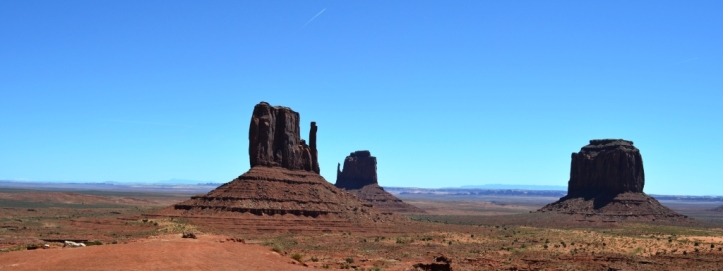
The view from the valley floor is spectacular. Merrick Butte, Sentinel Mesa and the East Mitten Butte are photographs just waiting to be taken. The trail is well marked with cairns and is well traveled with human and horse footprints. At about three locations, the trail moves into a dry wash (arroyo) where a cairn marks the arroyo entry, and another cairn marks the exit.
After completing more than three-quarters of the three-mile loop, we found ourselves hiking northerly along a wash. I was in front, walking through the sandy soil and Lynn was a few feet behind me. Looking to the southwest, high up on the hill, I could see the trail head and the RV parking lot near there. The trail we were hiking was taking us away from the trail head. That’s when I looked down to see the only human prints on the trail were my own, behind me. All the rest were hoof prints from the wild horses. Having just seen them traverse the area, it occurred to me that they had just been through here and obliterated the human prints in the sandy soil. On the other hand, I didn’t think we should be going north at this point on the trail. I mentioned to Lynn that we were likely no longer on the trail. Since we were in an arroyo, there would be no cairns until the trail exited the wash. I could see a few dozen yards ahead that it looked like the trail headed out of the wash. I asked Lynn to stay where she was, and I walked to where I could clearly see the trail leaving the wash. There was no cairn there. We were officially off the trail.
As I headed back toward Lynn, a half-dozen or so horses made another nearby appearance, from the southwest moving northeast, appearing to lead us back to the trail head. “That’s nice of them”, I thought to myself, knowing of course that they weren’t doing any such thing. The trail is well marked and we could see the trail head on the hillside to our southwest. I could see no reason for us to backtrack to find the exact point where we lost the trail. I decided that we would proceed directly south over the flat valley floor. We would have to intersect the trail at some point. We hadn’t walked 300 yards south when I spotted a couple of cairns ahead. Another few moments and we were back on the marked trail.

From there, it was less than ten minutes to the 3-mile sign where we would begin our long climb back to the trail head. A forty-minute climb brought us to the top where there was a lady coming to meet us. She was hoping we would take her photo with the Mitten Buttes behind her, and we were happy to accommodate. The lady reciprocated by taking our photo as well. It was still a good tenth-mile uphill climb from the trail head to the parking lot. The break was welcomed, and I would soon regret my comment to Lynn at the beginning of our hike that we aren’t much of an excuse for hikers if we can’t walk from the hotel parking lot to the trail head parking lot.
John Steiner

Hard to believe we still have wild horses – great to see that we do!!
Coincidentally, I just happened to see a story on the network news the other day about how the wild horses are doing so well in the wild, that they are becoming a problem to livestock ranchers. There’s a program of relocation going on in some areas due to their growing numbers. (This is the sanitized version of the story. )