 Fargo, North Dakota.
Orchard Glen Park in south Fargo is my new favorite park. I finally got the opportunity to get some aerial views from this park of many apple trees. Finding a clear spot overhead would be a challenge, I thought. When I got there, I realized I’d forgotten that there is a paved road that loops around the majority of the apple trees. The road is wide enough to support a vertical ascent without having to worry about getting tangled in the trees.
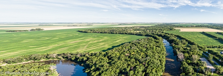
Technically, this view is not “of the park”, but a view of the farmland and the tree-lined Red River of the North as it winds its way on the eastern edge of the park. This view looks basically southerly toward the headwaters not that many miles south of this park.
About the photo: Captured with my Mavic Air drone’s camera, the photo is a panoramic view of two images stitched together in Adobe Lightroom. Shooting in manual mode is easy with the drone. Its lens opening is fixed at f/2.8, and I always leave the ISO set to 100 for minimum noise. That’s not a problem for low light as I don’t have the authority for night flight anyway. But I digress… the one variable I can set is the shutter speed. I simply rotate the setting until I get a clear image that’s not washed out on the view screen I have in front of me. The exposure that looked the best set at 1/590 sec.
This image is best viewed enlarged. If your browser supports it, select the image to enlarge it.
John Steiner

Looks so green
North Dakota has two colors, green in summer, white in winter. >grin< Thanks for taking the time to comment.
No worries have a great day
I envy your ability to take pictures from a drone. Of course, I imagine using one to take pictures of a large car gathering from many vantage points.
Truth is, there is a pesky regulation that stipulates certain requirements for drone images of gatherings. They are too onerous for a single pilot to meet for any large gathering, but a small gathering is doable, and is something I plan to do.
Wow, great photo. That’s interesting you can do a panoramic from a drone. I’ve only done them on a fixed tripod that I then rotated.
Thanks!
There is a mode of flight on my drone called “tripod mode.” It works quite well when winds are light. In that mode, the drone’s stability is enhanced at the expense of other factors that are all intertwined. When you yaw the drone on its vertical axis, it maintains its horizontal position over the ground acting as if the drone itself was mounted on a tripod.
The drone has an automatic panorama mode that will actually take the shots and stitch them into a single JPEG file, but I prefer to capture the images in RAW mode and stitch them together in Lightroom so that I have more control over the final image.
That is just amazing. I never knew they could do this. Thank you for the information.
Stunning aerial image, John!
Thank you!