

Cochiti Pueblo, New Mexico
In a recent photo challenge, I featured a trio of photos taken at Kasha-Katuwe Tent Rocks National Monument. Travel about an hour north of Albuquerque, New Maxico and you will find the 4600 acre (18 km sq) public land managed by the federal government’s Bureau of Land Management.

The area is beautiful with rock formations that have eroded into cone-shaped “tents”, some small as seen in the photo above, and some quite large as you will see in the gallery.
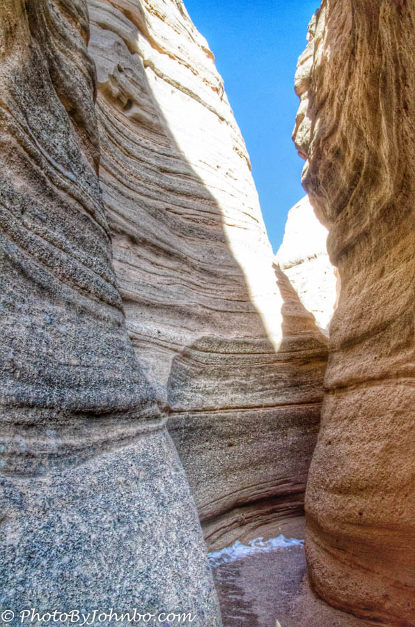
One of the more interesting trails is Canyon Trail. It’s a short one-way hike into a slot canyon that climaxes in a steep climb to the top of a mesa. Even if you aren’t in physical shape to make the climb out of the canyon, don’t bypass the hike completely. Even the views at the lower end of the trail are spectacular. Simply turn around and retrace your steps out when the trail gets too difficult for you to continue. Two easier hikes, Cave Loop Trail, and the wheel chair accessible Veterans Memorial Trailheads are both located at the parking area. Canyon Trail’s trailhead is a short distance away along the Veterans Memorial Trail. All of these trails are 1.5 miles (2 km) or less in length, so you might find yourself hiking all of them in an afternoon.
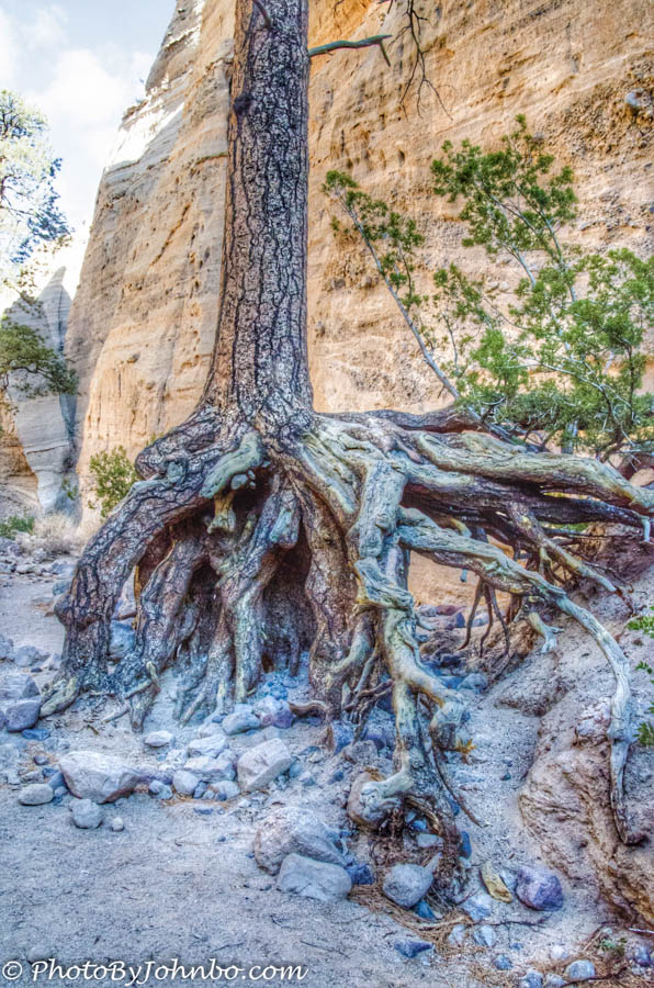
Be mindful of the weather in the area. The low terrain is subject to flash flooding. The narrow channel in the slot canyon can generate high speed, deep water flows. The tree in the photo above demonstrates how the water has eroded the base to the point of exposing over four feet of tree roots.
One note of importance to pet owners, dogs are not allowed in the park, properly identified service animals are the only exception to this rule.
I submit for your approval, a gallery of images taken on our hike at Kasha-Katuwe Tent Rocks National Monument. Click on an image in the gallery to enlarge it and to scroll through the gallery of images.


Click here to check out the New Mexico BLM website.
A note on this gallery of images… Last week I read an article online about an application called Snapseed. This photo editing software is a free app from Google for smartphone or tablet use.
As an experiment, I used Lightroom on a Windows 8.1 computer as usual to prep my raw file images, taken with a Nikon D7000. I exported them as high resolution jpg files and transferred them to my iPad. From there, I loaded them into Snapseed and experimented with the tools available there.
I especially like the looks of the images after applying the HDR tool. The image can be easily adjusted after Snapseed applies the default settings to the images. The hardest part was getting the processed images back to my Windows computer so I could include the modified images in my Lightroom catalog. I discovered that if I “open” the iPad in Windows while the iPad is connected with the sync cable, and then use the Windows search tool looking for today’s date, the images saved by snapseed show up and they can be easily copied back to my Windows computer and imported into the Lightroom catalog for future reference.
I would appreciate any feedback you might have on the use of Snapseed and your take on the resulting images in the gallery.
John Steiner

Lovely shots =)
Beautiful photos! Thank you for sharing this. I will have to go visit this place one of these days.
Thanks! I had not heard of Tent Rocks before we stopped at my sister’s place on our way to Arizona. I had asked them to recommend nearby places to photograph. Knowing your love of birds, I know you will appreciate the next place in New Mexico that I will feature. With that, I will leave you in suspense, my friend.