
Fort Laramie, Wyoming.
On our way into the Fort Laramie National Historic Site, we came across this sizeable three-span bridge over the North Platte River. Our first view of the bridge was from the north side, with little space to park. We would soon discover a small parking area with some informational plaques that told the story of the bridge. One of the plaques reads in part, “Erected 1875. This bridge was a vital link between Cheyenne, Fort Laramie, and the military outposts, Indian agencies, and gold fields of the Black Hills Dakota region.“
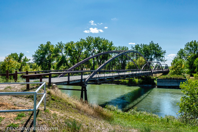
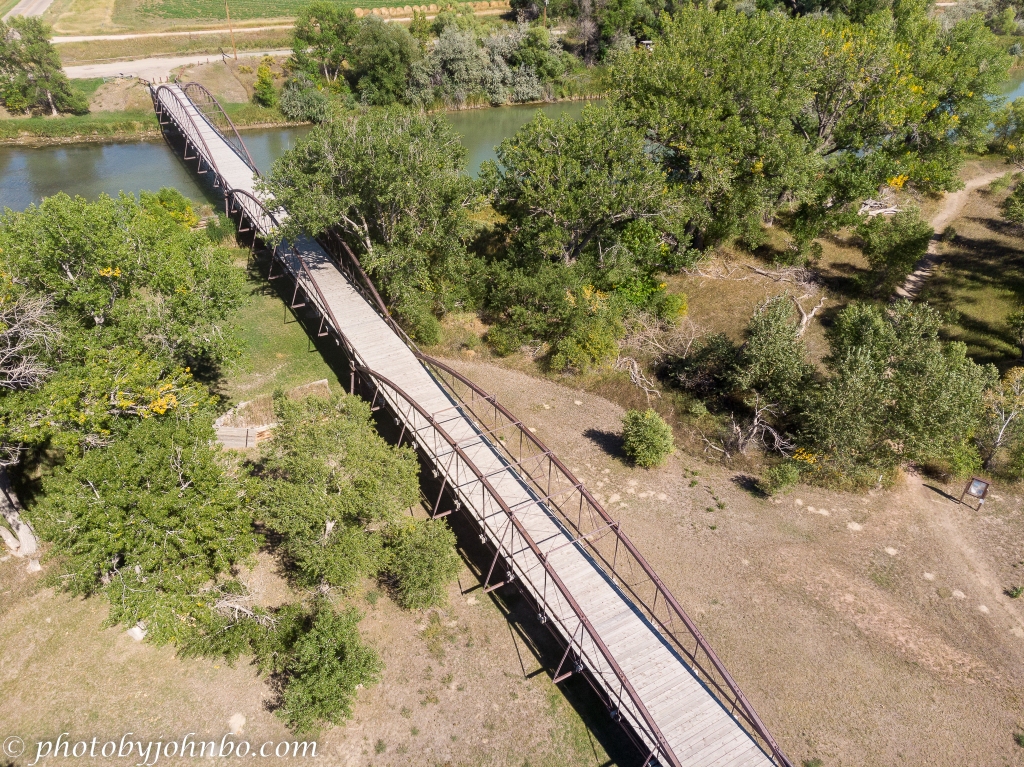
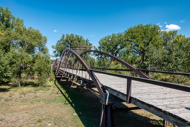
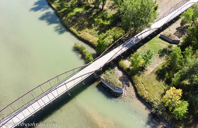
Consisting of two 125-foot (38 m) spans and one 150-foot (46 m) span, the bridge is constructed of wrought iron and native pine. The 12-foot (4 m) roadway carried the typical daily traffic across the North Platte River when the bridge was finally completed in 1876.

The bridge was replaced by a concrete and steel bridge (just visible to the right in the image above) in 1958, and a complete restoration of the original structure provided pedestrian use for the historic bridge in 1969.
The bridge has a total length of 400 feet (122 m) and covers a much larger area than the summer width of the North Platte. No doubt it is as long as it needed to be to handle the widened river during the spring snowmelt.
At some point in the history of the bridge, two large boat-shaped planter boxes sit astride the bridge. There were no markers or other indications of their purpose.

The small parking area features access to a small park and a trailhead that, as you can see from the drone shot, accesses the trail that parallels the southern side of the North Platte.
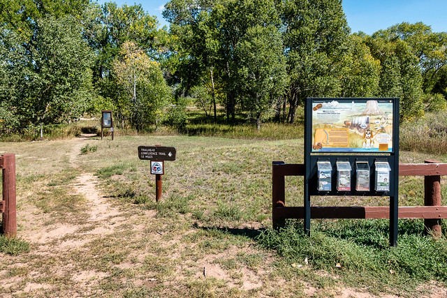
Wayside markers provide information as you walk along the 1.6-mile (2.6 km) hiking trail. It’s an easy walk on relatively level ground. The trail is a lasso loop that goes from the parking lot at the bridge to the confluence of the Laramie and North Platte Rivers and back. The view along the river is shaded by cottonwood and willow trees that grow along the river banks.
For a closer look at any of the images or check out the metadata click on any photo. You can also view and scroll through all of the images on my Flickr site in 2K HD by clicking here.
John Steiner

I’ve walked across this bridge! I love the overhead photos, it really shows how long the bridge is.
It is a bit of a walk. Fun stopover before going to the fort.
[…] The Old Army Bridge – Fort Laramie National Historic Site — Journeys with Johnbo […]
We visited Fort Laramie but somehow managed not to see this bridge – what a shame we missed it!
It is hidden by the trees along the road to the fort. I can see why it could be missed. I happened to see the arches sticking above the terrain. I’m a sucker for old bridges.
Your drone photos of the bridge are so well done! Maybe I will get a drone one of these days …
They are a bit of a hassle to set up and to get used to flying, but the photos they can produce are always an interesting perspective.
Hello there, wonderful location. The overhead photos look great. Was there a seaparate camera on the drone or is this the drone camera itself?
My drone happens to have a nice 4K camera for video and it creates great HD still images.
What a great bridge. I’m glad they kept it for foot traffic. Nice images.
Thanks, Anne. These old bridges are always a surprise when we wander nearby.
😊
Haven’t been there but I always enjoy seeing old bridges.
I find it the most fun to be able to stop and launch the drone. I’ve got a couple of bridge images this trip as well, but on the day we went by, it was too windy to launch the drone.
I appreciate that someone had the good sense to preserve the historic old bridge even when the more modern version was built right next to it!
Fortunately in the past, the powers that be have had the foresight to do just that. These days, we seem to find less of that preservation attitude. It is an unfortunate historic loss when they tear down these pieces of our history.
What fun. I love bridges, too, and you have captured some lovely shots of this one. Can you imagine using a wooden bridge built in 1875 clear up to 1958? They must have had to continually replace the wood in order for it to be safe. Love the drone. 🙂
I love to take bridge photos with the drone for it’s all-encompassing perspective. Unfortunately, not every place allows them, and often when we get to a site where I could use one, it might be too windy. That happened twice on our journey this month, and so far, no drone images.
Wind would be the enemy of drones. So would regulations. Do the remote signals ever interfere with small plane controls?
No, drone telemetry is on a completely different frequency band.
Why do they ban drones? I can understand the ban in governmental places that might reveal secrets, but under most circumstances maybe in residential areas as well to protect sunbathers, LOL.
Drones have been banned due to carelessness and lack of safe operating procedures from drone pilots. As usual the few have created restrictions for the many licensed pilots who operate safely within the laws.
Sounds like what happens in every aspect of life, doesn’t it?
Indeed!