
Phoenix, Arizona.
Lynn and I borrowed a friend’s van to carry some of our belongings home to Fargo when we sold our house in Buckeye last March. When we got back to Fargo, I hopped on a plane and flew to Mesa where a friend (with the van) was keeping our car in his driveway. From there, I would drive back to Fargo for the second time in a week.
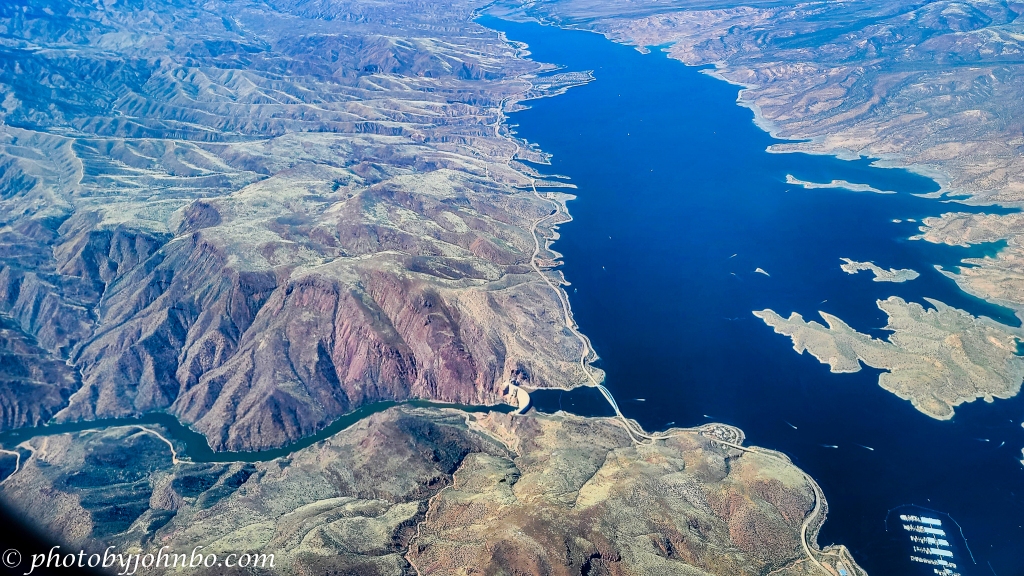
On the plane trip inbound to Phoenix, I got some photos of the chain of man-made lakes on the Salt River. This week Cellpic Sunday begins a multi-part series of images captured while inbound to Phoenix.
The dams and reservoirs on the Salt River are a major source of water for the Phoenix metropolitan area. As we flew toward Mesa, I happened to notice the largest lake and dam in the watershed. The Theodore Roosevelt Dam was constructed in the early 1900s to equalize the flow of water and provide irrigation that turned the desert into farmland.
At the time, the world’s tallest dam was dedicated in 1911, and in 1996, it gained an additional 357 feet (108 m) which added to Lake Roosevelt’s storage capacity by 20 percent. The lake at maximum depth is 188 feet (57 m) and has 128 miles (206 km) of shoreline. I gleaned these basic facts from the webpage of the Salt River Project, managers of the watershed. More details and history can be found here.
About the photo: Captured by my Samsung S20U, I processed it in Lightroom and Luminar Neo. The dam looks small from altitude, but if you saw it from the downriver side of the Salt River, it certainly would not seem small at all. Click on the image above to view it in 2K HD on my Flickr site (and get a preview of upcoming Cellpic Sunday images.)
I encourage fellow bloggers to create their own Cellpic Sunday posts. I never have a specific topic for this feature, and the only rules are that the photo must be captured with a cell phone, iPad, or another mobile device… If you have an image from a drone or even a dashcam, that’s acceptable as well. The second rule is to link your challenge-response to this post or leave a comment here with a link to your post in the comment.
John Steiner

[…] John’s Cellpic Sunday […]
An amazing water body John 🙂
More to come in the next couple of weeks. 🙂
That’s an excellent phone photo, especially captured from a plane – so crisp and clear!
I am always impressed with the quality of the camera in my S20U. I’ve been tempted to upgrade it, but as is often said, “If it ain’t broke, don’t fix it.” 🙂
Very true – buy a newer model and you might regret it!
Nice capture. I like how when there are no trees you can see the contours of the earth.
Luminar Neo’s Structure tool did a great job of bringing out those contours. Photos from airplanes often look flat because there is so little difference in elevation changes in the terrain compared to the distance from the camera to the subject.
The lower altitude as we approached the Phoenix metro and the tweaks in Luminar really brought out the terrain details.
[…] Johnbo’s CellPic Sunday […]
I love taking pics from the airplane windows! The world looks so different from above. You may already know this but you can keep your phone location on while in airplane mode, which tells you where you are. Spectacular pics and thanks for the air tour, John. Here is mine this week: https://secondwindleisure.com/2022/05/08/sunday-stills-monthly-color-challenge-teal-or-aqua-rhymes-with/
I discovered that by accident some time ago, and glad I did. For these lake images in the next couple of weeks, it was invaluable in helping me determine which lake is which. 🙂
Definitely! I only discovered this last August as we flew from Phoenix to Seattle then Spokane. At 500+ mph, you might miss something.
I saw some fascinating views of the Rocky Mountains on the trip, but I only got one shot. I’d had my camera off, and by the time I turned it on and got it booted, we were all but south of the Rockies.
[…] Shared with #ThursdayDoors, #PPAC, #CellpicSunday. […]
John, Beautiful aerial view of Roosevelt Lake and Dam. Thank you for sharing this.
Here’s my entry for Cellpic Sunday this week: https://natalietheexplorer.home.blog/2022/05/06/weekday-walk-exhibition-place/
Thank you, Natalie!
[…] John’s Cell Pic Sunday […]
[…] One Word Sunday: sea/see and Cellpic Sunday 5.8.22 […]
Gorgeous view and photo, John. Here’s my very different but still watery contribution for today. Happy Mother’s Day to your lovely wife.
janet
Interesting view and facts. Here’s my entry
https://photobyjohnbo.wordpress.com/2022/05/08/cellpic-sunday-241/
If and when I travel by air again, I will follow your example and use my cellphone to take photos out of the window.
The newest cameras do such a nice job even through that thick multi-paned plexiglass window.
Amazing how that relatively small wall (compared to the hills that surround it) can inundate such a vast area!
Indeed, I am always fascinated by the power of a dam to hold back so much pressure.
Aerial views are always arresting. Like you, I find it better to use a mobile phone camera out of the window of a plane than a camera.
Indeed!
[…] Posted for John’s Cellpic Sunday Challenge […]
This is an amazing shot. So beautiful!
Here is mine:
Thanks, Sofia!
[…] Johnbo’s CellPic Sunday Photography Challenge – 8th May 2022 […]
Beautiful image John, I’ve only just found your challenge… here is my entry….
Thank you for joining in on the challenge, and thank you for the follow!
You are welcome… so pleased to have found your challenge xx
[…] CELL PIC SUNDAY […]
Hi John, Those dams are so impressively huge. We’ve been to Hoover Dam but not Roosevelt Lake. The aerial views are unusual because you knew what you were seeing and they are so close. I look forward to seeing the rest of the series. 🙂 Here’s my link for this week. https://alwayswrite.blog/2022/05/11/wqw-17-whats-that-smell/
Thank you for the information.
Lovely aerial view.
Love the leading lines and varied blue colour.
Thanks, Philo!
You are welcome John
[…] post is part of John.S’s CELLPIC SUNDAY photo […]
My contribution
Wow, very impressive for a phone pic! I’ll try to join in on the challenge in future 🙂
Thanks, Kaylin. Looking forward to seeing your first post from your cell phone for the challenge!